
VIA DEI FORI IMPERIALI

Via dei Fori Imperiali is a road in the center of Rome connecting the Piazza Venezia to the Colosseum, with important ruins lying on either side of the street, and regular excavations taking place to hopefully find the artifacts that still remain underground.
This road was created by Benito Mussolini, the founder of the fascist party who ruled Italy from 1922 until 1943.
THE FASCES
The fasces is a symbol originating from ancient Rome, depicting a bundle of sticks tied around an axe. This symbolized vast political power through unity.
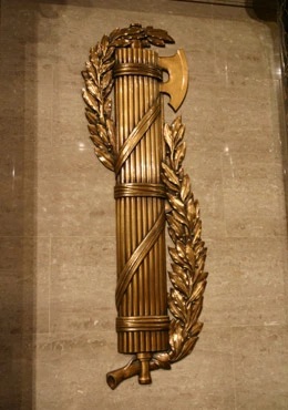
Mussolini, inspired by this symbol, named his movement the Fascists.

The fasces has been adopted by governments around there globe, notable appearing on the Lincoln Memorial.

The underlying idea: a bundle is stronger than any individual stick.
THE BASILICA MAXENTIUS
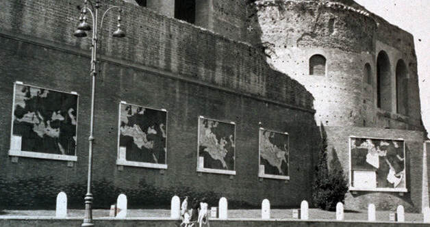
One of the important buildings along the road is the Basilica Maxentius; it originally was a temple built by Maxentius and created into a church by Constantine I, and houses the Mussolini maps.
These maps show how the Roman Empire evolved, from around 760 BCE to 117 CE and beyond. The first four were installed in 1934, with the last being unveiled in 1936.
Mussolini’s plan with these maps was to show the expansion of Rome, and associating his reign and architectural achievements with those of the ancient Romans.
1ST MAP: THE BEGINNING

2ND MAP: THE PUNIC WAR

3RD MAP: THE DEATH OF AUGUSTUS

4TH MAP: THE REIGN OF TRAJAN

5TH MAP: LA TERZA ROMA
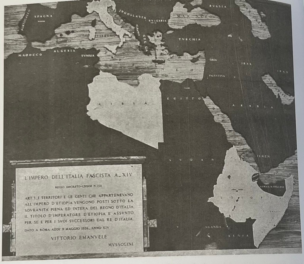
This included Albania, Croatia, the Balkans, France’s Corsica and Nice, Greece, and eastern Africa from Tunisia, Libya and Egypt, through Sudan to Ethiopia and Somalia. A creation of a new Rome “to the east of the existing one.”
Mussolini viewed himself as a conqueror, aiming to reclaim Italy’s status as the domineering world power. These maps centered Italy’s national identity and history.
After the 2nd World War and the death of Mussolini, the fifth map was removed out of protest for his ideology and regime.
CONCLUSION
Unfortunately the rise of fascism is all too relevant today, as far right movements continue to gain power across the globe.
Mussolini’s ambitions draw modern comparisons to the actions of President Trump (Canada, Greenland, the Gulf of Mexico), as well as Vladimir Putin’s invasion of Ukraine.
It’s remarkable how quickly history can repeat itself.
Bibliography
Rome, Jonathan. “The Life and Death of Via Dei Fori Imperiali: 1932-2015.” Rome on Rome, February 17, 2015. https://romeonrome.com/2015/02/the-life-and-death-of-via-dei-fori-imperiali-1932-2015.
Rome, Jonathan. “Mussolini’s Architectural Legacy in Rome.” Rome on Rome, January 13, 2016. https://romeonrome.com/2016/01/mussolinis-architectural-legacy-in-rome/.
Kelly, John. “The Fasces, from Ancient Rome to Mussolini’s Italy to New Deal America – The Washington Post.” The Washington Post, October 1, 2022. https://www.washingtonpost.com/dc-md-va/2022/10/01/symbolic-fasces-lincoln-memorial/.
Minor, Heather Hyde. “Mapping Mussolini: Ritual and Cartography in Public Art during the Second Roman Empire.” Imago Mundi 51, no. 1 (January 1999): 147–62. https://doi.org/10.1080/03085699908592907.
Bodenschatz, Harald. “Public Housing in Fascist Rome: A European Perspective.” Joelho Revista de Cultura Arquitectonica, no. 8 (December 26, 2017): 96–111. https://doi.org/10.14195/1647-8681_8_6.
Klein, Mike. “Out and about in a Provincial Empire of Fascism | Worlds Revealed.” Library of Congress Blogs, March 16, 2022. https://blogs.loc.gov/maps/2022/03/out-and-about-in-a-provincial-empire-of-fascism/.
Sulzberger, C.L. “ITALY SAID TO PLAN A GREATER ALBANIA.” The New York Times, July 29, 1940. https://brooklyn.ezproxy.cuny.edu/login?url=https://www.proquest.com/historical-newspapers/italy-said-plan-greater-albania/docview/105484130/se-2.
Agnew, John. “The Impossible Capital: Monumental Rome under Liberal and Fascist Regimes, 1870-1943.” Geografiska Annaler, Series B: Human Geography 80B, no. 4 (January 1998): 229–40. https://doi.org/10.1111/1468-0467.00042.
“Maps and Mussolini, Via Dei Fori Imperiali, Rome – Walks in Rome (Est. 2001).” 2024. Walks in Rome (Est. 2001). October 26, 2024. https://www.walksinrome.com/blog/maps-and-mussolini-via-dei-fori-imperiali-rome.

Leave a comment